Parish Boundaries
<< Back to Parish Information
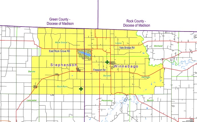
| North: | Starting at the intersection of North Zimmerman Road and the Illinois/Wisconsin state line: east on the Illinois/Wisconsin state line to the Laona/Shirland township line (Sugar River). |
| East: | Starting at the intersection of the Illinois/Wisconsin state line and the Laona/Shirland township line (Sugar River): follow the Laona/Shirland township line (Sugar River) to the Harrison/Shirland township line; follow the Harrison/Shirland township line (Sugar River) to Harrison Road; south on Harrison Road to Route 75; east on Route 75 to Harrison Road; south on Harrison Road to Oliver Road; west and south on Oliver Road to the Harrison/Burritt township line. |
| South: | Starting at the intersection of Oliver Road and the Harrison/Burritt township line: west on the Burritt/Harrison township line to the Pecatonica/Durand township line; west on the Pecatonica/Durand township line to Trask Bridge Road; west on Trask Bridge Road to Cedarville Road; west on Cedarville Road to North Dakota Road. |
| West: | Starting at the intersection of Cedarville Road and North Dakota Road: north on North Dakota Road to East Rock Grove Road; west on East Rock Grove Road to North Zimmerman Road; north on North Zimmerman Road to the Illinois/Wisconsin state line. |