Parish Boundaries
<< Back to Parish Information
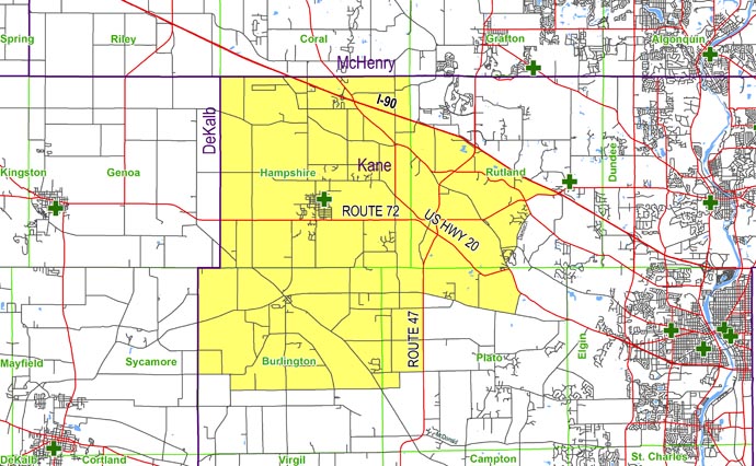
| North: | Starting at the intersection of the Kane/DeKalb county line and the Kane/McHenry county line: east on the Kane/McHenry county line to the Hampshire/Rutland township line. |
| East: | Starting at the intersection of the Kane/McHenry county line and the Hampshire/Rutland township line: south on the Hampshire/Rutland township line to Interstate 90; southeast on Interstate 90 to Route 72; west on Route 72 to Big Timber Road; southeast on Big Timber Road to Damisch Road; southwest on Damisch Road to Reinking; southeast on Reinking Road to US 20; southeast on US 20 to Switzer Road; south on Switzer Road to Plank Road; west on Plank Road to Route 47; south on Route 47 to Plato Road. |
| South: | Starting at the intersection of Route 47 and Plato Road: west on Plato Road to Pease Road; south on Pease Road to Ellithorpe Road; west on Ellithorpe Road to McGough Road; north on McGough Road to Marcy Road; west on Marcy Road to the Kane/DeKalb county line. |
| West: | Starting at the intersection of Plank Road and the Kane/DeKalb county line: north on the Kane/DeKalb county line to the Kane/McHenry county line. |