Parish Boundaries
<< Back to Parish Information
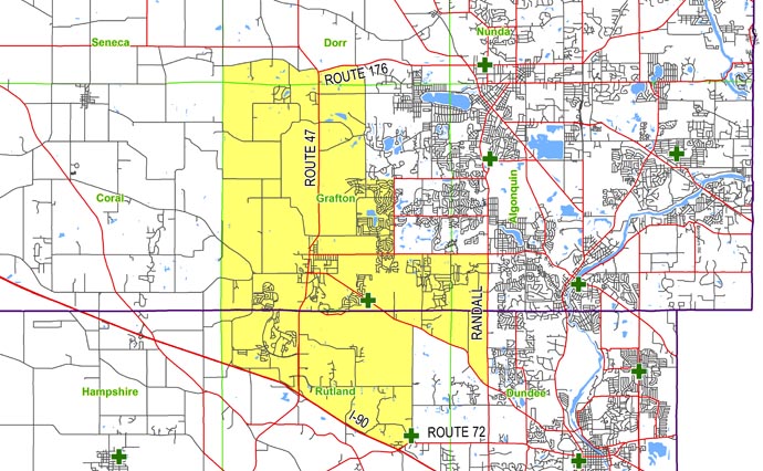
| North: | Starting at the intersection of the Seneca/Dorr township line and Pleasant Valley Road: east on Pleasant Valley Road to Route 47; south on Route 47 to Route 176; east on Route 176 to Haligus Road. |
| East: | Starting at the intersection of Route 176 and Haligus Road: south on Haligus Road to Ackman Road; east on Ackman Road to Lakewood Road; south on Lakewood Road to Algonquin Road; east on Algonquin Road to Randall Road; south on Randall Road to Huntley Road. |
| South: | Starting at the intersection of Randall Road and Huntley Road: northwest on Huntley Road to Galligan Road; south on Galligan Road to Willey Street; west on Willey Street to Railroad Street; south on Railroad Street to Route 72; west on Route 72 to Interstate 90; northwest on Interstate 90 to the Hampshire/Rutland township line. |
| West: | Starting at the intersection of Interstate 90 and the Hampshire/Rutland township line: north on the Hampshire/Rutland township line to the Coral/Grafton township line; continue north on the Coral/Grafton township line to the Seneca/Dorr township line; continue north on the Seneca/Dorr township line to Pleasant Valley Road. |